„The reception of German atlases in 19th century France. The French cartographic complex“ lautet der Vortragstitel von Prof. Dr. Gilles Palsky (Paris) am Mittwoch, 2. November 2016, im Rahmen der 7. Gothaer Kartenwochen auf Schloss Friedenstein. Die Kartenwochen werden gemeinsam von Forschungsbibliothek und Forschungszentrum Gotha veranstaltet. Beginn ist um 18:15 Uhr im Herzog-Ernst-Kabinett der Forschungsbibliothek, der Eintritt ist frei. Alle Interessierten sind herzlich willkommen.
Eine kurze Einführung in den englischsprachigen Vortrag:
This paper will first provide a few insights on the production of atlases in 19th century France. In this period, many observers considered that, after a brilliant 18th century, France was much behind with regard to its geographic education and cartographic production. In the early 19th century, French maps were often compared with the English production, but in the middle of the century, Germany turned to be the reference in the field of cartography, with special mention to the Gotha publishing house. This superiority was then investigated in the scientific literature: questions were raised about its causes and the ways to catch up. The admiration expressed in the beginning of the period quickly became a complex, a humiliating sense of dependency, especially after the defeat of the 1870 war. French geographers then planned to realize atlases that might rival with German works, a goal that was not achieved before the turn of the 20th century.
Gilles Palsky is Professor of Geography at Paris 1 Panthéon-Sorbonne University and he is a member of the research unit Epistemology and History of Geography. He chaired the History of Cartography Commission of the French Committee of Cartography (1999-2007). Since 2013, he is a trustee of the International Society for the History of the Map. His research revolves around the role of images in the building of geographical knowledge and the development of thematic mapping, 19th-21st century. He is also engaged in theoretical issues in cartography: visualization of spatial dynamics, participative mapping, semiology of graphics.
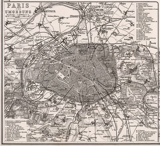
Abbildung: Adolf Stieler & C. Vogel, Paris und Umgebung. Frankreich in 4 Blättern, Stieler’s Hand-Atlas, 1873, 36 x 42 cm, Maßstab 1 : 1,500,000, David Rumsey Historical Map Collection, via Wikimedia Commons